Created Summer 2020
The Sanborn Maps Navigator was created by 2020 Library of Congress Junior Fellow Selena Qian to explore the United States through historic maps and newspaper photographs. Qian’s tool combines 32,000 maps from the Sanborn Fire Insurance Atlases collection and 1,494,585 photographs from the Newspaper Navigator dataset.
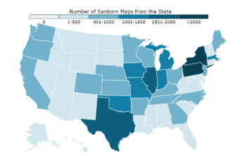
On this site, you can explore the Sanborn Fire Insurance Maps geographically. By clicking on different areas on the map, or on the items in the "Results from ..." section, you'll be able to see the Sanborn atlases from those areas. The newspaper photo will also update as you change geographic locations, randomly generating from within the chosen location.
For the project code and documentation, please visit the Sanborn Navigator repository on the Library of Congress GitHub.